Tuesday, September 1, 2026

Meadow closures in Rocky Mountain National Park are now in effect

Rocky Mountain National Park posted this on their social media today:
Happy September! Cool temperatures and crisp air mean that fall is just around the corner. It's also time for the park's annual meadow closures.

Meadow closures are in effect from September 1 through October 31 to prevent the disturbance and harassment of elk during their fall mating season. Meadow closures are also in place for the safety and enjoyment of park visitors who are out viewing elk and other wildlife during this special time of the year.

Meadow areas are closed in Horseshoe Park, Upper Beaver Meadows, Moraine Park, Harbison Meadow and Holzwarth Meadow between the hours of 5 p.m. to 10 a.m. During these hours, meadow areas will be closed to all travel on foot or via horseback off established roads and trails.

Planning to go fishing along Fall River, Big Thompson River, and the Colorado River? Fishing locations that are accessed by walking through closed meadow areas are also closed to fishing access between the hours of 5 p.m. to 7 a.m.

Wildlife viewing is one of the most popular activities that visitors come to Rocky to enjoy each fall. Remember to keep your distance and view wildlife with respect. When viewing elk, keep back at least 75 feet (23 m). These are wild animals and they can be very aggressive during the fall rut. If wildlife is reacting to you, you are too close. It is our responsibility to keep our distance.

As always, the use of elk calls, spotlights, or the use of vehicle headlights to spot wildlife is prohibited within Rocky Mountain National Park.


              ************************************************************************************

Check out our online trail guides:


Sunday, August 30, 2026

Public Assistance Requested to Account for Individuals Following Grand Canyon Flash Flood

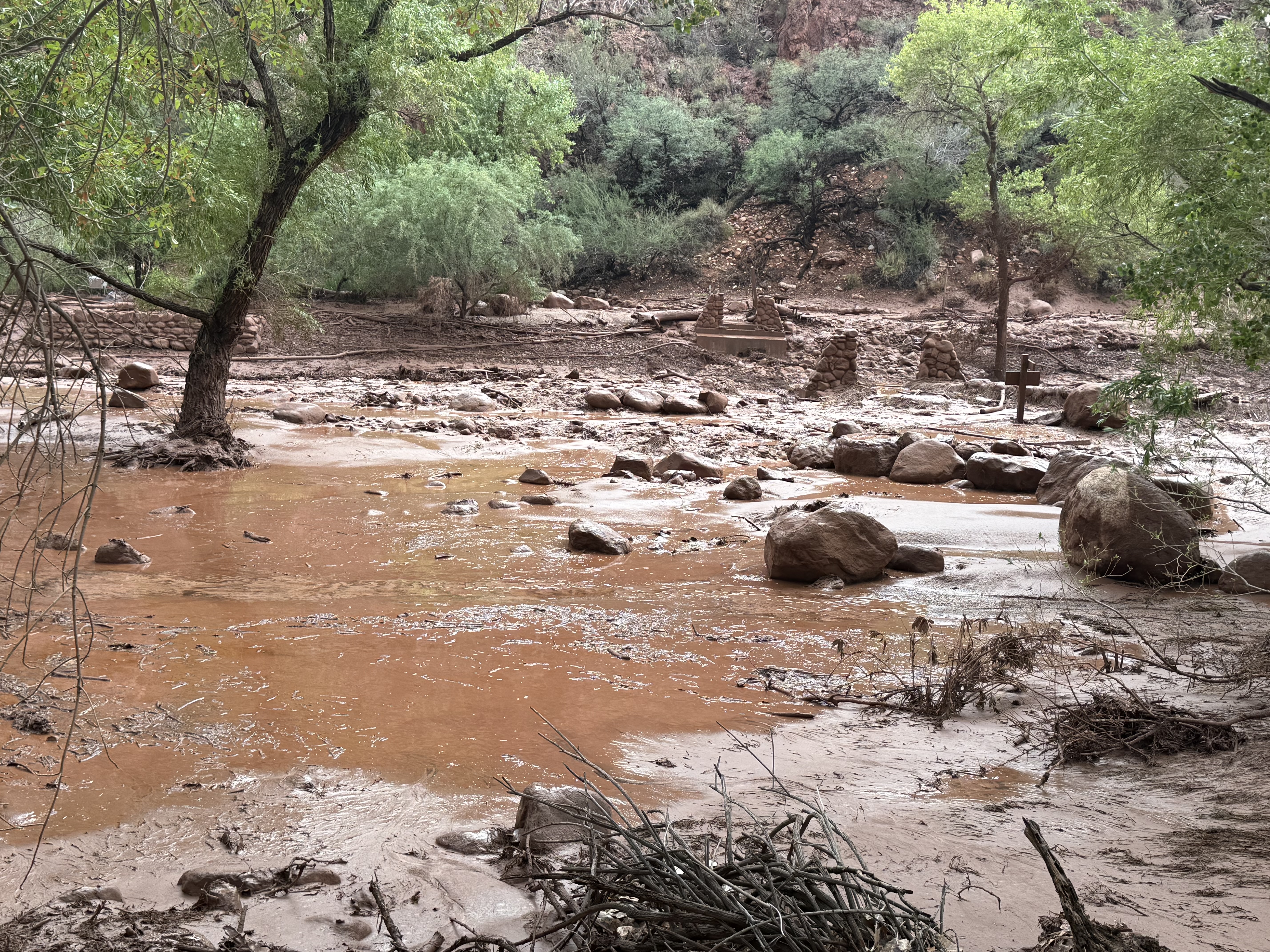
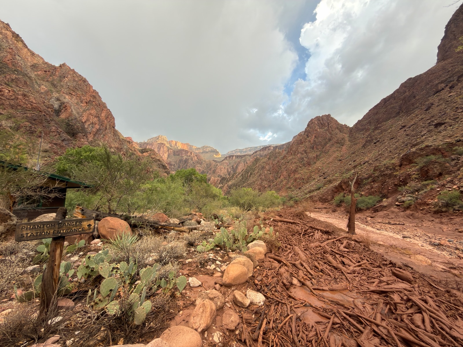
The National Park Service is asking the public to provide information for more than 20 individuals who may be missing or unaccounted for following a significant flash-flood event in Bright Angel Canyon and the Phantom Ranch area on August 29.

Grand Canyon National Park staff, in coordination with the Arizona Department of Public Safety, are continuing evacuation and response efforts and working to account for individuals who may have been in the affected area.

The National Park Service is asking anyone who knows of hikers or backpackers who were in the inner canyon along the Bright Angel Creek corridor on August 29, as well as anyone who had a campground reservation in the affected corridor, to provide information to the National Park Service Investigative Services Branch (ISB). This includes individuals who may have been traveling along the North Kaibab Trail from the North Kaibab Trailhead to Phantom Ranch, staying at Bright Angel Campground, or traveling or staying in the area known as “the Box” north of Phantom Ranch.

If you know of anyone who may have been hiking or backpacking in these areas, please contact the NPS Investigative Services Branch Tip Line:

NPS ISB Tip Line: 888-653-0009

Email: e-mail us

When submitting a tip, please provide any information you have about the individual, including their name, approximate location, travel plans, group size, clothing or backpack description, or when they were last known to be in the area. You do not have to provide your name.

Additional info:

A significant flash-flood event occurred in Bright Angel Canyon and the Phantom Ranch area on August 29, beginning at approximately 2:30 p.m.

As of the morning of August 30, 62 individuals have been evacuated from Phantom Ranch and the lower North Kaibab Trail. Additional individuals are scheduled to be evacuated this morning from Cottonwood Campground and Phantom Ranch in coordination with the National Park Service and Arizona Department of Public Safety. Evacuees are being transported to the Maswik Lodge Cafeteria on the South Rim, where the American Red Cross is coordinating assistance. No injuries have been reported as of the latest available information.
Phantom Ranch, Bright Angel Campground, the Phantom Ranch Canteen and cabins, and the entire North Kaibab Trail from the North Kaibab Trailhead to Phantom Ranch are closed until further notice. The Black Bridge and Silver Bridge crossing the Colorado River are also closed until further notice. There is currently no estimated reopening date for these areas and other inner canyon closures may be necessary. For the latest trail and closure information, visit the park's Key Hiking Messages webpage.

The flash flood resulted in significant impacts to infrastructure throughout Bright Angel Canyon. Nearly all footbridges spanning Bright Angel Creek were destroyed, eliminating hiker access across the creek. Grand Canyon National Park staff are continuing to assess damage to trails, bridges, utilities, facilities and other infrastructure.

The Colorado River is currently closed to river traffic until further notice due to metal structures and debris entering the river. River parties already in the canyon are receiving direction through river operations rangers and the Grand Canyon River Alert system. Visitors with upcoming river trips should contact their commercial outfitter or NPS River Permits for trip-specific information.

Additional thunderstorms and heavy rainfall are possible today and Monday, which could result in additional flash flooding, debris flows, rockfall and changing trail and river conditions.


              ************************************************************************************

Check out our online trail guides:


U.S. Forest Service and National Forest Foundation launch the first National Forests and Grasslands Passport

The U.S. Forest Service and the National Forest Foundation (NFF) announced the launch of the National Forests and Grasslands Passport, a free digital experience designed to inspire visitors to discover more of America’s national forests and grasslands while earning commemorative digital badges along the way.

Available through the OuterSpatial mobile app, the National Forests and Grasslands Passport transforms every visit into a rewarding experience, allowing visitors to check in and earn exclusive digital badges for each national forest and national grassland they explore.

“As an avid fan of the National Park Service Passport Program, I am excited to announce the introduction of the digital U.S. Forest Service Passport Program. More than 164 million people visit our 154 national forests and 20 national grasslands each year bringing back with them stories, family memories and oftentimes plans to return or explore a new Forest Service destination,” said Forest Service Chief Tom Schultz. “Now, millions of people are able to track their visits on their mobile devices through the National Forests and Grasslands Passport, and we are so excited to welcome the next generation of adventurers through this engaging, digital experience.”

Each national forest and grassland has its own specially designed badge, inspired by the iconic Forest Service entrance signs that have welcomed visitors for generations. The artwork reflects the landscapes, wildlife, plants, and other features that define each forest and grassland, creating a collection as distinctive as the places themselves.

Additionally, users will be able to view their total visit number ranked in a leaderboard with other challengers. Visitors are encouraged to log in all their past visits to unlock digital badges to build their own personal collection; however, only check-ins within the geographic coordinates of the national forest or grassland will earn a certified green checkmark.

To learn more about the National Forests and Grasslands Passport and to download, visit: www.nationalforests.org/passport


              ************************************************************************************

Check out our online trail guides:


Friday, August 28, 2026

Colorado Parks and Wildlife investigating bear attack in Estes Park

Colorado Parks and Wildlife is investigating a bear attack after an adult bear entered an Estes Park home Thursday morning. Around 4:30 a.m., a bear broke into a house on the western side of town through an unlocked, closed window on the first floor. The homeowner, a woman in her 80s, reported to CPW officers she awoke to the bear in the kitchen on the second floor. The bear charged the woman, scratched her across the stomach and knocked her to the ground, according to the victim. She told officers the bear then left the house through the first floor window.

The victim called 911 and Larimer County Sheriff’s deputies responded to the scene. No bear was found. She sought medical treatment for her abdominal injuries.

CPW has requested the assistance of the U.S. Department of Agriculture Animal & Plant Health Inspection Service (APHIS) in locating the bear involved.

Heavy bear activity has been reported in the area, with multiple bears breaking into occupied homes and vehicles over the past few days. CPW officers have set traps to remove bears posing an immediate public safety risk.

“As we continue to navigate this extraordinary bear year, please continue to be vigilant in removing food and trash that may attract bears to your property,” said CPW Area Wildlife Manager Jason Duetsch. “Wildlife officers are working tirelessly to respond to an unprecedented number of bear reports, and we are counting on the community to help mitigate conflict."

Colorado is experiencing an unprecedented bear conflict year, largely due to drought conditions depleting natural food sources for bears. As they begin to enter hyperphagia, bear activity is expected to increase while they search for 20,000 calories per day before denning. Bears can take greater risks in seeking out food during this time, driving them into neighborhoods and populated areas.


                *******************************************************************************

From Montana to New Mexico, the American Rockies stretch for more than a thousand miles. Within this spectacular mountain range are thousands of miles of hiking trails. With such an overwhelming number of options, how will you find and choose the most scenic and rewarding hikes?

Ultimate Hiking Guide to the Rocky Mountains takes all the guesswork out by focusing on some of the most amazing hikes across this range, and provides you with a handpicked list of options that will allow you to make the most of your trips in the Rockies:

Wednesday, August 26, 2026

Forest Service reduces Gold Mountain and Elk Fire closure areas

The Grand Mesa, Uncompahgre and Gunnison (GMUG) National Forests have reduced previously established closure areas associated with the Gold Mountain and Elk wildfires. Updated closure boundaries went into effect August 24 at 5 p.m. and remain in place through Dec. 1, unless conditions allow an earlier adjustment.

The reductions reopen several popular destinations while still restricting access where fire activity and firefighter operations require additional space.

Western Area (Gold Mountain Fire) - The western closure area is located east of U.S. Highway 550 in Ouray County. This area includes National Forest lands near Dexter Creek, Horse Thief Trail and portions of the Uncompahgre Wilderness. Roads, trails and recreation sites in the Silver Jack, Cimarron and Cow Creek drainages remain closed while firefighters continue work on the Gold Mountain Fire. See closure order for full detailed boundary description and map.

Eastern Area (Elk Fire) - The eastern closure area, associated with the Elk Fire, is located west of State Highway 149 and includes National Forest System lands around Big Blue Creek as well as portions of the Ridgestock Driveway and Uncompahgre Peak trail. Several high‑use destinations in this region are now open, including Nellie Creek Road and the Nellie Creek Trailhead, the Uncompahgre Peak Trail and Uncompahgre Peak itself, as well as Wetterhorn Peak, the Wetterhorn Peak Trail and Matterhorn Peak. These locations are accessible from the south and east and are outside the adjusted closure footprint. See closure order for full detailed boundary description and map.

Several recreation sites remain closed under the updated order, including Beaver Lake Campground and Fishing Site, Big Cimarron Campground, Cimarron Forks Camping Area, Clear Lake/Rowdy Lake Trailhead, Courthouse Trailhead, Dexter Creek Trailhead, East Fork Trailhead and East Fork dispersed camping, Independence Trailhead, Jackson Lookout/Cabin, the Middle Fork Cimarron dispersed camping area, Owl Creek Pass dispersed camping, Owl Creek Vista Trailhead, Silver Jack boating, camping and picnic sites, Vista Point Trailhead, West Fork Trailhead and the West Fork Cimarron dispersed camping area. For full list of roads, trails and recreation sites, please see full closure order here.

The GMUG National Forests are currently under Stage 1 Fire Restrictions.


              ************************************************************************************

Check out our online trail guides:


Tuesday, August 25, 2026

On this date in hiking history: The Three Musketeers complete the Long Trail

The following is an excerpt from Ramble On: A History of Hiking.

Accounts of Green Mountain Club outings throughout its first several decades show that women participated in tramps as often as men. This included thru-hikes of the Long Trail in Vermont, which was completed in 1930 as the first long-distance footpath in the United States. Though the final 10-mile segment leading to the Canadian border was only a blazed route at the time, Kathleen Norris, Hilda Kurth and Catherine Robbins became the second group of trampers to thru-hike the entire 272-mile trail in 1927. It took 32 days for the “Three Musketeers,” as they affectionately became known as, to complete their extended trek. During the trip, the three young ladies became media sensations, as newspapers across America covered their story. Their feat would inspire many other females to become “end-to-enders” in the years that followed.

The Three Musketeers: When they needed a rest they would pull out a ukulele and sing college prep songs until they were re-energized:


                *******************************************************************************

Virtually no one went hiking before the 19th century. What occurred that inspired ordinary people to take a walk through the woods for pleasure? Ramble On: A History of Hiking explores the rich history of hiking, and how it evolved into one of the most popular pastimes in the world.


Monday, August 24, 2026

Dallas Trailhead Area closed to public during construction work

The Grand Mesa, Uncompahgre and Gunnison National Forests’ Ouray Ranger District will temporarily close National Forest System lands in the immediate vicinity of Dallas Trailhead on County Road 17 beginning Aug. 24 at 9 a.m. to ensure public safety during a Ouray County construction project.

The closure is necessary while crews operate heavy equipment in the vicinity of the trailhead as part of a Federal Emergency Management Agency hazard‑mitigation grant aimed at reducing recurring flooding on Corbett Creek at County Road 17.

A full closure details and a detailed map can be found here.

The closure will remain in effect from Aug. 24 at 9 a.m. through Nov. 1 unless the order is rescinded earlier. During this period, visitors should plan ahead, avoid the described area, and use alternate trail access points.

The Forest Service appreciates the public’s patience and cooperation as partners complete this important safety‑driven mitigation work.

For more information, contact the Ouray Ranger District in Montrose at 970‑240‑5300.


              ************************************************************************************

Check out our online trail guides:


Saturday, August 22, 2026

Intro to 14er Gear: The 10 Essential Systems

In this Colorado Fourteeners Initiative video, Justin from the Denver REI Flagship store provides an overview of the first nine essential systems: navigation, nutrition, hydration, illumination, sun protection, first aid supplies, fire starters, repair kits and emergency shelter. It's a good (refresher?) course for anyone heading out on the trail, especially if you're planning to try a fourteener:


              ************************************************************************************

Check out our online trail guides:


Wednesday, August 19, 2026

On this date in hiking history: William O. Douglas begins his 22-mile hike to protest an extension of Highway 101

On this date in 1958, U.S. Supreme Court Justice William O. Douglas led a 22-mile trek along the Olympic coast in Washington, just west of Olympic National Park, to protest a proposed extension of Highway 101. This backpacking trip along the rugged coast took three days to complete, but was successful in accomplishing the goal of the roughly 70 participants.
Here’s a pretty cool documentary film of Douglas’s historic hike – both for its historical significance, and the scenery:


                *******************************************************************************

Virtually no one went hiking before the 19th century. What occurred that inspired ordinary people to take a walk through the woods for pleasure? Ramble On: A History of Hiking explores the rich history of hiking, and how it evolved into one of the most popular pastimes in the world.


Sunday, August 16, 2026

Colorado 14er hiking use down in 2025

Hiking use on Colorado’s 14,000-foot peaks fell three percent overall in 2025—down 9,000 to an estimated 256,000 hiker-use days—compared to the prior year, according to Colorado Fourteeners Initiative's 11th edition of its hiking-use report. Closure of the Mount Blue Sky Scenic Byway contributed greatly to the decline, which offset higher climbing use on several of the most popular fourteeners. The 2025 estimate is the lowest tally CFI has recorded since the nonprofit began the hiking-use-estimate program in 2015.

The race for most popular fourteeners last year was again a photo finish, with Mount Bierstadt narrowly edging out Quandary Peak. Use on both peaks was estimated to be in the 30,000 to 35,000 hiker-use days range. Bierstadt’s trail counter recorded almost 31,000 hiker days, while Quandary’s trail counter recorded an estimated 30,500 hiker days. Both counters were operational 100 percent of the monitored period. The Decalibron Loop’s Mount Democrat came in third place with an estimated use at 20,000 to 25,000 hiking-use days, which was up more than 5,000 days compared to 2024. Grays and Torreys peaks and Mount Elbert remained in the third tier of use in 2025, suggesting that 15,000 to 20,000 climbers hiked those mountains.

In 2025, an estimated 59 percent of statewide hiking use (152,400 hiker days) occurred on the 12 fourteeners situated closest to the metro area, specifically those in the Front Range, Tenmile Range, Mosquito Range, and Mount Elbert, which is a geographical outlier in the Sawatch Range. The remaining 46 peaks accounted for 103,600 hiker days.

Compared to 2024, hiking use in 2025 fell in four mountain ranges: Front Range (-13,500 days, -16 percent), San Juan Mountains (-10,500 days, -30 percent), Sawatch Range (-2,000 days, -3 percent), and the Elk Mountains (-1,500 days, -17 percent). Hiking use was up in three ranges: Mosquito Range (+9,000 days, +40 percent), Sangre de Cristo Range (+5,500 days, +65 percent), and the Tenmile Range (+4,000 days, +15 percent).

Some of the ups and downs in hiking use in recent years relate to discrete openings and closures of individual peaks. For example, access to Mount Lindsey in the southern Sangre de Cristo Range was restored last year under an electronic waiver program after being closed for five seasons due to landowner liability concerns. This led to a rebound in hiking use in 2025 as people were able to lawfully return to climb the mountain. Meanwhile, access to La Plata Peak was closed starting in mid-August due to a wildfire that started from a campfire located close to CFI’s trail counter. The trail remained closed by the Forest Service through the end of the monitoring season in early October due to hazard mitigation work. Other noticeable changes can be attributed to the way CFI has tweaked its modeling program. For example, during CFI’s first nine hiking use reports the modeling program assumed that hikers were climbing Mount Blue Sky by the 17-mile round-trip route from Echo Lake. Last year CFI switched to using the 5.5-mile round-trip ascent from Summit Lake, which is more commonly done. That caused Mount Blue Sky to jump from the fourth tier (10,000 to 15,000 hiker-use days) into the second tier (20,000 to 25,000 hiker-use days). This change in assumption may have overstated climbing use in 2024, because, even when the road is open to Summit Lake, access is limited and permitted, a factor not considered by the modeling program. CFI recently obtained permission from Denver Mountain Parks to place a trail counter on Mount Blue Sky above Summit Lake, which should provide greater clarity regarding actual hiking use on this peak. To be clear, CFI does not attempt to estimate the number of people driving to the top of the road, a mere 138 feet below the summit, and then hiking to the summit.

For the 2025 hiking season, CFI began breaking out North Maroon Peak as a separate summit. Previously it had been lumped in with Maroon Peak when North Maroon was not considered a “ranked” fourteener.

CFI maintained a network of 20 counter locations in 2025, down from 23 counters in 2024 due to the departure of a key staff member who worked on the project. Counters that had observed data for more than 90 percent of the season included Bierstadt (100 percent), Quandary (100 percent), and Pikes (100 percent). Counters that collected between 60 and 90 percent of the season included: La Plata (95 percent), Elbert (88 percent), Shavano (84 percent), Grays/Torreys (76 percent), Handies—Grizzly Gulch (76 percent), Redcloud/Sunshine (76 percent), Princeton (71 percent), Democrat & Bross (65 percent), Huron Peak (64 percent), Sherman (63 percent), Blanca/Ellingwood (62 percent) and Lindsey (60 percent). Counters were not placed last year on Wilson, Sneffels, Challenger/Kit Carson or Handies (American Basin).

CFI’s most recent estimate of hiking use suggests a statewide economic impact of $69.4 million directly attributable to hiking fourteeners based on economic expenditure studies performed by Colorado State University economists John Loomis and Catherine Keske. Their 2009 study found that climbers of Quandary Peak near Breckenridge spent an average of $271.17 per day for gasoline, food, lodging, equipment, and other retail purchases. This expenditure estimate has not been updated in more than 15 years, so it is likely significantly understated.

CFI’s hiking use projections are based on the combination of several data sources. 1) CFI collected hour-by-hour data during the 2025 hiking season using compact infrared trail counters that were placed at 20 locations adjacent to summit hiking trails servicing 23 fourteener peaks. Hiking use is estimated for the period between May 25 and October 4. Missing data were modeled using a linear model incorporating week number, day of the week, holiday and use levels on other similar peaks, which has shown to be statistically accurate. 2) Hiking-use projections for all other fourteeners were based on crowdsourced “14er checklists” submitted to the 14ers.com website by more than 26,900 individual hikers. Estimates for peaks without trail counters were determined using a trend line calculated by the relative frequency of reported hiking use on all peaks using data points as anchors for peaks that had trail counters in 2025.

CFI began deploying compact infrared trail counters as part of a pilot program in 2014 at five locations: Grays/Torreys, Castle, Quandary, Redcloud/Sunshine, and Handies Peaks (American Basin). The program was expanded in 2015 to five additional locations: Mount Elbert (3 locations), Mount Democrat, and Handies Peak (Grizzly Gulch). Additional funding in 2016 allowed CFI to add 10 new monitoring locations: Mounts Sneffels, Sherman, Princeton, Antero, and Shavano, La Plata, Huron and Wilson Peaks, Challenger Point/Kit Carson Peak and Blanca Peak/Ellingwood Point. In 2017, the Antero counter was moved to the Winfield approach to La Plata Peak. In 2018, two new counters were deployed on Pikes Peak (Barr Trail and Devil’s Playground), while the La Plata (Winfield) counter was moved to the West Ridge of Quandary, and the Princeton counter was moved to Mt. Lindsey. In 2020, the West Ridge of Quandary counter was moved to a better location on Mount Princeton, while a new counter was deployed to Mount Bierstadt. In 2024, the Bierstadt counter was replaced for a third time—two counters were stolen over consecutive years—and counters were placed on Bross and the Winfield approach to La Plata. Due to reduced staff capacity, the following counters were not placed in 2025: Handies (American Basin), Sneffels, Wilson and Challenger/Kit Carson. CFI uses the term “hiker-use days” to report hiking use on the fourteeners. This represents one person hiking one peak on one day. Anecdotally, we know that individual enthusiasts may hike multiple fourteeners over the course of a given year, including climbing the same peak multiple times. Using “hiker-use days” reports the number of days of hiking use that occurred but does not represent the number of individual people who hiked fourteeners that year.


                *******************************************************************************

From Montana to New Mexico, the American Rockies stretch for more than a thousand miles. Within this spectacular mountain range are thousands of miles of hiking trails. With such an overwhelming number of options, how will you find and choose the most scenic and rewarding hikes?

Ultimate Hiking Guide to the Rocky Mountains takes all the guesswork out by focusing on some of the most amazing hikes across this range, and provides you with a handpicked list of options that will allow you to make the most of your trips in the Rockies:


Friday, August 14, 2026

On this date in hiking history: The final link in the Appalachian Trail is completed

On this date in 1937, a Civilian Conservation Corps crew finished construction on a two-mile section of the Appalachian Trail between Spaulding and Sugarloaf Mountains in Maine, thus connecting the final link along the entire trail. At that time, the footpath traveled roughly 2025 miles, from Mount Oglethorpe in Georgia to Mount Katahdin in Maine. However, the Appalachian Trail Conservancy website notes that the route is constantly changing, and estimates that 99% of it has been rebuilt or relocated since its initial completion, including the reroute to its current southern terminus at Springer Mountain. As you can see in this photo, women were active in building the trail, especially before the CCC became involved in 1933:
Here’s the Bates Outing Club conducting maintenance work on the Appalachian Trail, circa 1939. According to the video description, “The black liquid they're smearing on their faces and arms at the 42-second mark is probably pine-tar fly dope (nasty stuff!).”


                *******************************************************************************

Virtually no one went hiking before the 19th century. What occurred that inspired ordinary people to take a walk through the woods for pleasure? Ramble On: A History of Hiking explores the rich history of hiking, and how it evolved into one of the most popular pastimes in the world.


Thursday, August 13, 2026

On this date in hiking history: Two grizzly bear attacks in Glacier National Park

On this date in 1967 the unthinkable occurred. Two women, in separate incidents, were killed by grizzly bears while backpacking in Glacier National Park. The incidents were detailed in the best-selling book, Night of the Grizzlies, by Jack Olsen. Fifty years after the events of that night, PBS broadcast an outstanding documentary with the same name. As a hiker, this can be a little difficult to watch at times:


                *******************************************************************************

Virtually no one went hiking before the 19th century. What occurred that inspired ordinary people to take a walk through the woods for pleasure? Ramble On: A History of Hiking explores the rich history of hiking, and how it evolved into one of the most popular pastimes in the world.


Sunday, August 9, 2026

On this date in hiking history: The first recorded use of the word “mountaineering"

The following is an excerpt from Ramble On: A History of Hiking.

The joint publication of Lyrical Ballads by William Wordsworth and Samuel Taylor Coleridge in 1798 is widely recognized as the birth of Romanticism in English literature. In addition to being close friends, both poets held nature in the highest regard, and both enjoyed exploring the Lake District on long walking excursions.

In the 1805 version of The Prelude, Wordsworth described himself as a “mountaineer,” a term he didn’t use in the original 1799 version of this unpublished poem. It’s very possible that he may have adopted this expression during the intervening years from his friend and writing partner, Samuel Taylor Coleridge. On August 9, 1802, Coleridge sent a letter to Robert Southey, another one of the so-called “Lake Poets,” which described an extended rambling excursion he took in the Lake District. During the outing, Coleridge made the first known ascent of 3163-foot Scafell, the second-highest peak in England. In the letter, he casually remarked that he had "spent the greater part of the next day mountaineering." The Oxford English Dictionary now recognizes this as the first recorded use of the word “mountaineering" to describe this relatively new and emerging sport. Other Romantic poets, such as John Keats and Lord Byron, would also describe themselves as “mountaineers.”


                *******************************************************************************

Virtually no one went hiking before the 19th century. What occurred that inspired ordinary people to take a walk through the woods for pleasure? Ramble On: A History of Hiking explores the rich history of hiking, and how it evolved into one of the most popular pastimes in the world.


Friday, August 7, 2026

Parks Canada charges hikers after grizzly bear encounter with off-leash dog in Banff National Park

Two hikers with an off-leash dog have been charged after coming close to a grizzly bear in Banff National Park. Parks Canada charged them after a TikTok post generated several million views after being published on July 21.

James Eastham, a spokesperson for Parks Canada’s Lake Louise, Yoho and Kootenay field unit, told the CBC that “Failure to keep your pets leashed in the national parks poses risks to pets and wildlife. Bears and other wildlife may react aggressively toward dogs they view as threats, resulting in their injury or death.”

Canadian law states that people must keep their pets on a leash of three metres or less in national parks. If found guilty, the two hikers could face a fine of up to $25,000!

In other words, it's not illegal to take a dog on a hike in grizzly country in Canada, only that it must be kept on a leash. However, multiple studies and historical analyses by wildlife biologists indicate that the presence of dogs more than doubles the odds of a human-bear conflict, and frequently acts as a catalyst for defensive attacks. Most recently, a "New analysis of more than 300 bear encounters suggests our canine companions often increase odds of conflict and rarely serve as early warning systems many recreationists assume." You can find more statistics here.

In America, dogs are not allowed on backcountry trails in most national parks. However, I've seen several hikers flout this law in places like Glacier, Grand Teton, Rocky Mountain and the Great Smoky Mountains.

Here's a CTV News report, which includes the social media video that led to the charges:


              ************************************************************************************

Check out our online trail guides:


Thursday, August 6, 2026

Rocky Mountain National Park to Implement Another Phase of the Poudre Headwaters Project; Some Areas in the Kawuneeche Valley Will Be Closed August 24-30

Rocky Mountain National Park will be implementing another phase of the Poudre Headwaters Project during the week of August 24-30, 2026. Young greenbacks require food, space, and protection from non-native predators and competitors, like brook trout, which outcompete greenbacks. Removal of brook trout is a key factor for recovery success.

This project takes place on the west side of RMNP and involves the removal of all non-native fish from the Grand Ditch and upstream and downstream tributaries inside the park. Once removed, native Greenback cutthroat trout will be reintroduced into its native range in the headwaters of the Cache la Poudre River.

The first phase of this project inside RMNP took place during August 2025. This year’s project will be very similar to last year’s project. Because of the level of activity associated with the implementation of the Poudre Headwaters Project, all areas and trails within the project zone will be closed to all uses beginning on Monday, August 24 through Sunday, August 30. The Colorado River Trail and the Grand Ditch will be closed.

To remove non-native fish, aquatic biologists will apply a piscicide called rotenone to the 14.3-mile Grand Ditch system and its upstream and downstream tributaries. Rotenone is commonly used by state and federal land management agencies. This project will be led by biologists with the U.S. Forest Service. Other partners include Colorado Parks and Wildlife and U.S. Fish and Wildlife Service. This project is possible thanks to support provided by Trout Unlimited and Rocky Mountain Conservancy.

While this project is underway, the following trails will remain open: East Inlet Trail, North Inlet/Tonohutu Trail, Green Mountain Trail, Coyote Valley Trail, Onahu Trail, and Timber Lake Trail. The Holzwarth Historic Site and Harbison Meadows Picnic Area will also remain open. Fishing access will remain open in all areas along the Colorado River located south of the Colorado River Trailhead, including near the Holzwarth Historic Site and Coyote Valley.

For detailed hiking information on all the trails on the west side of Rocky, please click here.

For a map of the closure, please click here.


                *******************************************************************************

From Montana to New Mexico, the American Rockies stretch for more than a thousand miles. Within this spectacular mountain range are thousands of miles of hiking trails. With such an overwhelming number of options, how will you find and choose the most scenic and rewarding hikes?

Ultimate Hiking Guide to the Rocky Mountains takes all the guesswork out by focusing on some of the most amazing hikes across this range, and provides you with a handpicked list of options that will allow you to make the most of your trips in the Rockies:

Wednesday, August 5, 2026

On this date in hiking history: Earl Shaffer becomes the first person to thru-hike the Appalachian Trail

The following is an excerpt from Ramble On: A History of Hiking. [Note: Amazon is currently offering the book at a 29% discount]

After World War II, many soldiers came home after serving overseas and began heading to the mountains for reasons that were vastly different from previous generations. Many veterans sought the wilderness as a way of escaping or coping with the horrors of war they had experienced. One such individual was Earl Shaffer, the man who would become the first person to thru-hike the entire length of the Appalachian Trail. In 1941, Shaffer volunteered
with the U.S. Army and served as a forward-area radar technician in the South Pacific. In addition to the horrors he witnessed himself, the Pennsylvania native also suffered the loss of a close childhood friend, who was killed during the invasion of Iwo Jima. A couple of years after the war had ended, Shaffer read an article about a handful of adventurers who had hiked the entire Appalachian Trail in a series of “section hikes,” and decided that he would try to do it himself in one continuous “thru-hike.” The following year, in 1948, he accomplished this goal by hiking the entire route in 124 days. In his trail journal, which eventually became a book, Shaffer wrote that the war had left him “confused and depressed.” He thought that a long-distance hiking trip might provide a remedy, stating that he wanted to “walk the army out of my system, both mentally and physically.” In 1965, Shaffer reprised this historic feat by walking the “long brown path” in just 99 days. On the 50th anniversary of his first thru-hike, Shaffer hit the trail once again. This time, at the age of 79, he completed the 2158-mile trek in 173 days.


                *******************************************************************************

Virtually no one went hiking before the 19th century. What occurred that inspired ordinary people to take a walk through the woods for pleasure? Ramble On: A History of Hiking explores the rich history of hiking, and how it evolved into one of the most popular pastimes in the world.


Sunday, August 2, 2026

National Park Foundation Awards More Than $10 Million to Spark Innovation Across the National Park System

The National Park Foundation is excited to launch dedicated funding for parks and park partners to collaborate on innovative projects that will strengthen parks, expand what is possible, and ensure these extraordinary places endure for generations. The inaugural cohort, announced today, includes 18 grants totaling more than $10 million awarded to support 21 national parks.

National parks are rooted in natural, historic, and cultural wonders, but they originated as a novel idea, and their future depends on continued innovation. Often called "America's best idea," the national park concept set the blueprint for protecting extraordinary places and sharing them with the world.

With the support of generous donors and partners, NPF is helping parks carry that spirit forward by creating more room to innovate, collaborate, and experiment. These grants provide funding directly to those who know parks best, empowering them to test new approaches, implement scalable technologies, and share what they learn so parks are stronger, and visitors can have better experiences.

NPF has received more than 200 proposals for innovation funding so far. Among those submissions, 18 projects were identified for immediate funding, with an initial focus on real-time information and traffic management, connectivity, data-informed decision-making, and more. These first projects include the following:

* Friends of Acadia and Schoodic Institute will work with Acadia National Park to deploy sensors, predictive analytics, and communication tools that give visitors and park managers real-time information about congestion and wait times along key corridors.

* Grand Canyon Conservancy will expand the ways that visitors can engage with Grand Canyon National Park by increasing connectivity and introducing digitally integrated interpretation of the park, enabling visitors to learn more and go deeper into the story of the iconic landscape.

* Glacier National Park Conservancy will help Glacier National Park deploy bypass lane transponders and badge readers at park entrances, automate passenger counts on shuttle buses, and install real-time parking displays at visitor centers

* Friends of Virgin Islands National Park will install Starlink satellite internet at seven land sites and five marine sites in the remote Virgin Islands National Park to offer connectivity for visitors and to improve emergency communications.

Funding for the inaugural cohort came from NPF's generous donors and partners, including Lilly Endowment Inc. View the full list of projects here.

NPF first invested $2 million in pilot projects led by the National Park Service and Preservation Maryland to advance technologies and experiment with novel equipment across multiple park sites in support of emergency response, asset management, and more efficient park operations. Interest in the pilot proved the need and potential impact of continued, dedicated investment in innovative technologies and creative solutions.

With growing support from NPF's donors and partners, including Robert and Kitty Brunswick, Mr. Cody J Smith, The Ball Foundation, and Arconic Foundation, NPF will award additional grants to parks and park partners in the coming months to support innovation in other focus areas, including natural resource management and interpretation.

NPF will also facilitate learning groups that bring together grant recipients to share information, ideas, and lessons learned to inform and inspire other parks.


              ************************************************************************************

Check out our online trail guides:


Friday, July 31, 2026

Celebrate Colorado’s 150th anniversary by visiting state parks for free on August 3, joining 14er Climb: Summit 2026, a statewide 14er challenge

To celebrate Colorado Day and the state's 150th birthday, Colorado Parks and Wildlife (CPW) is offering free entry to all Colorado state parks on Monday, Aug. 3, 2026. CPW is one of many sponsors of 14er Climb: Summit 2026, a Colorado Outdoor Recreation Industry (OREC) event celebrating Colorado’s 150th anniversary and America’s 250th anniversary.

The state legislature created Colorado Day to mark the anniversary of statehood, granted in 1876 by President Ulysses S. Grant. The state recognizes this annual holiday on the first of the month, and state parks celebrate the occasion with free entrance on the first Monday of August.

14er Climb: Summit 2026 on August 1
Celebrate Colorado’s 150th and America’s 250th anniversaries by joining this statewide 14er hiking challenge. Whether you hike a peak or choose the Flat 14ers option, we welcome Coloradans of all abilities to get outside, honor our shared history, and celebrate the future we’re building together.

Learn more and see which summit you want to tackle first: https://cpw.info/4vZHpXu

Free State Park Entry on August 3
This free entry day is an opportunity for visitors to immerse themselves in the beauty of Colorado state parks and their diverse landscapes. All other park fees remain in effect, including camping reservations, boat and off-highway vehicle registrations, and hunting and fishing licenses. CPW also has apparel, stickers and postcards honoring this historic event available at cpwshop.com.

CPW urges all state park visitors to act as stewards of our state’s land, wildlife, and water. By balancing outdoor recreation with mindful conservation, we can all protect Colorado's natural beauty. Here are some outdoor tips to help you recreate responsibly.

***  To thank U.S. military members for their dedicated service and sacrifices, Colorado Parks and Wildlife (CPW) is continuing to offer free admission to all Colorado state parks for active-duty military, veterans, and National Guard members during the entire month of August.


              ************************************************************************************

Check out our online trail guides:


Wednesday, July 29, 2026

Amazon is offering "Ramble On" at a 29% discount right now

FYI: Amazon is currently selling Ramble On: A History of Hiking for just $11.99. That's 29% off the regular price!

It's not clear how long they will offer this discount, but it's usually only for a limited time.

This is a great opportunity to learn about the rich history of the world's greatest outdoor activity! You can also impress your friends with your knowledge of hiking the next time you're on the trail with them!


Tuesday, July 28, 2026

Hiker walks 10 miles after being impaled by trekking pole

A Billings, Montana man was impaled by a trekking pole on Granite Peak last week. The freak accident occurred roughly 2 miles below the summit. After assesing his injuries, David Cifaldi, a nurse, determined that he could walk back to the trailhead on his own power. That trip covered nearly 10 miles and took roughly six and a half hours to complete.

KCENNews in Texas provided a full report on the story. Warning: some of the images may be a little disturbing:


              ************************************************************************************

Check out our online trail guides: