Wednesday, October 30, 2024

Rocky Mountain National Park Announces Plans for Prescribed Burn this Friday and Saturday If Conditions Allow

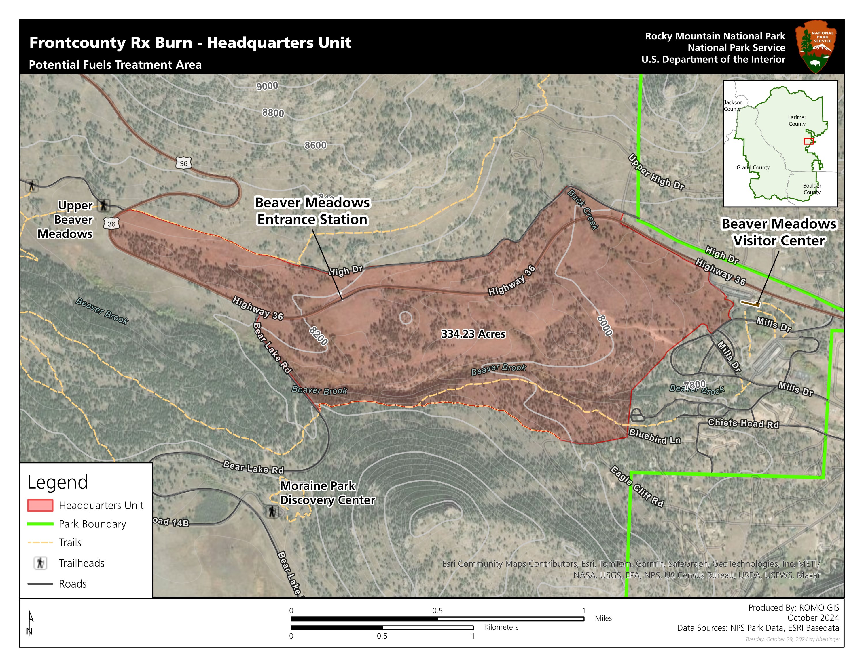
Based upon the potential for favorable weather and fuels conditions, fire managers at Rocky Mountain National Park are planning to conduct a prescribed burn beginning on Friday, November 1, 2024. Firefighters plan to burn approximately 100 acres of the 334-acre Headquarters Unit on Friday, November 1 and Saturday, November 2. This burn unit is located inside Rocky Mountain National Park, west of the Beaver Meadows Visitor Center and south of U.S. Highway 36. Because of the fuel type that will be burned, which include mainly grasses, heavy and prolonged smoke is not expected from this operation.
The primary goal of the project is to reduce the threat of wildland fire to adjacent communities and NPS infrastructure by using prescribed fire to reduce the amount of fuels available in this area. When fighting the East Troublesome Fire in 2020 and the Fern Lake Fire in 2012, firefighters were able to take advantage of previous and existing prescribed fire and hazardous fuels treatment areas that provided a buffer between the fires and the town of Estes Park. Prior hazard fuels projects were instrumental in stopping both fires from crossing Bear Lake and Trail Ridge Roads.

If conditions are favorable, ignitions are planned to occur on Friday, November 1 and Saturday, November 2. Firefighters will be on scene for the duration of the operation and will be patrolling the burned area overnight after operations conclude each day. Smoke from the prescribed burn will be visible throughout the day of the burn, mostly during the warmest part of the day. With cooler temperatures in the evening, smoke may linger and accumulate in low-lying areas.

Fire operations near the Beaver Meadows Entrance to RMNP may cause brief delays or divert outbound traffic through Fall River Entrance. Motorists should watch for fire vehicles on the roads and allow extra time for entering and exiting the park. Traffic control will be in place on U.S. Highway 36 within the burn area. Additional information will be shared on InciWeb at https://inciweb.wildfire.gov/incident-information/cormp-front-country-prescribed-fire and on RMNP’s official social media channels. NPS Fire Information Officers will be available at Beaver Meadows Visitor Center to answer questions.

For the safety of visitors and firefighters, park visitors will not be allowed to stop along U.S. Highway 36 within the burn area. Visitors will also not be able to walk within the burn area.

Smoke may be visible both inside and outside the park. Every effort will be made to minimize smoke impacts on visitors and the adjacent community; however, some smoke is anticipated to disperse east of the park. Smoke may affect your health: For more information see https://www.colorado.gov/pacific/cdphe/wood-smoke-and-health.

Safety factors, weather conditions, air quality, personnel availability and environmental regulations are continually monitored as part of any fire management operation.


              ************************************************************************************

Check out our online trail guides:


Friday, October 25, 2024

Trail Ridge Road is Closed to Through Travel for the 2024 Season

Today, Friday, October 25, Trail Ridge Road (U.S. Highway 34) inside Rocky Mountain National Park (RMNP) officially closed for the season to through travel.

With 11 miles of road located at elevations above 11,500 feet, few guard rails, and no shoulders, Trail Ridge Road is not designed to be an all-season road. Winter conditions of drifting snow, high winds and below-freezing temperatures occur above 10,000 feet. Trail Ridge Road is currently closed at Rainbow Curve on the east side of RMNP and at the Colorado River Trailhead on the west side of the park. Closure points on the road may fluctuate this fall, however the road is closed to through travel for the season.

Interested in taking a scenic drive? There are several popular scenic driving destinations open this time of year, including Bear Lake Road, Endovalley Road, Trail Ridge Road on the west side of RMNP from Grand Lake Entrance to the Colorado River Trailhead and Trail Ridge Road on the east side of RMNP to Rainbow Curve.

Trail Ridge Road normally opens the last week in May, weather permitting. In 2024, Trail Ridge Road opened on Friday, May 31.

Old Fall River Road closed to vehicles for the season on October 8. Trail Ridge Road and Old Fall River Road will remain open to bicycles, hikers, and people walking leashed pets through November 30. Leashed pets and bicycles are only allowed on the roads, not on side trails. On December 1, both roads will transition to "winter trail status." On Sunday, December 1, 2024, bicycles and leashed pets will no longer permitted to travel beyond the closed gates. Pedestrians, snowshoers and skiers will be welcome to recreate during the winter season on both roads.


Thursday, October 24, 2024

San Juan National Forest works toward resolution of land dispute after group lays claim to 1460 acres within forest

The U.S. Forest Service continues to manage a land dispute on the San Juan National Forest involving a fence that was erected in trespass and unlawfully impeded the public’s access to parts of the national forest north of Mancos, Colorado. U.S. Forest Service officials met with the parties that constructed the fence and the Montezuma County Sheriff on Wednesday, Oct. 9, and informed them in writing that the fence is in trespass and must be removed immediately. San Juan National Forest Service leadership has been engaged with members of the local community and will be updating area residents as resolution on this matter progresses.

“The Forest Service is deeply committed to maintaining access by the public to all lands on the San Juan National Forest,” said San Juan National Forest Supervisor Dave Neely. "We are actively working with the appropriate law enforcement agencies and the community to resolve this matter."

The individuals who constructed the fence and own lands adjacent to the San Juan National Forest identify themselves as “Free Land Holders” and assert that they have ownership or jurisdiction of approximately 1,400 acres of Forest Service-managed lands within the constructed fence line. Forest Service and Montezuma County records indicate that ownership of the subject land has been with the United States as part of the National Forest System since 1927.

These lands support long-standing livestock grazing for local ranchers and the area is popular for recreation including hiking, mountain biking, and cross-country skiing. It is within the Brunot Treaty area which assures hunting access for the Southern Ute Indian Tribe, Ute Mountain Ute Tribe, and Ute Indian Tribe.

San Juan National Forest leadership is keenly aware of community concerns and questions and takes this matter very seriously. The Forest Service is actively addressing the dispute according to legal and administrative procedures and will promptly provide additional information as circumstances warrant.

According to the Denver Post:
The Free Land Holders’ argument essentially comes down to whether or not the word “the” is capitalized when preceding “United States” on various historic documents. Pipkin believes the Founding Fathers established the country as “The United States of America” when they wrote the Articles of Confederation in 1777, which created a republic that he now belongs to.

But somewhere along the way, he said, the king of England tricked the new country into signing documents as “the United States of America” — lowercase T — creating a separate entity from the original republic.

“It’s not the same name,” Pipkin said during an interview on his property last week. “Totally different. That’s why the sheriff has no jurisdiction. That’s why the Forest Service has no jurisdiction. They work for the small ‘t,’ which is the king today. King Charles.”


              ************************************************************************************

Check out our online trail guides:


Monday, October 21, 2024

Forest Service acquires 19 acres in Collegiate Peaks Wilderness

The public recently gained 19.3 acres in Colorado’s Collegiate Peaks Wilderness following the White River National Forest’s acquisition of the Panama/Principal Lodes parcel from The Wilderness Land Trust.

The parcel is located in the Green Mountain area south of U.S. 82 (Independence Pass Road) and north of Lincoln Creek. Public access is now ensured on a popular social trail through the property, commonly called the Green Mountain Trail.

“It is great to see this sizeable and important addition to the Collegiate Peaks Wilderness come to fruition, allowing the Forest Service to move ever closer to securing the future for the Green Mountain area,” said White River National Forest Supervisor Scott Fitzwilliams.

“The Wilderness Land Trust first purchased the property in August 2020 and is thrilled to see it added to the wilderness. This sensitive alpine habitat will now be protected for future generations of wildlife and people. We’re grateful for our partnership with the White River National Forest on this, and many other projects, to ensure the future of Colorado’s wilderness areas,” said Brad Borst of The Wilderness Land Trust.

The White River National Forest has been working with The Wilderness Land Trust for several years to acquire private inholdings in the wilderness in the Green Mountain area. The 8.7-acre Grandview Lode was added to the wilderness in 2019, and 10.3-acre Spotted Tail Lode is awaiting transfer.

The 2.3 million-acre White River National Forest manages approximately 750,000 acres of designated wilderness across eight wilderness areas, more than a third of the land it manages.


Tuesday, October 15, 2024

Things To Know About Visiting Rocky This Month

Posted on Rocky Mountain National Park's social media today:
Planning for an October trip to Rocky? Fall is here and winter is just around the corner. Here are a few things to know:

- Alpine Visitor Center and the Trail Ridge Store are closed for the 2024 summer season. Beaver Meadows, Fall River, and Kawuneeche Visitor Centers are open daily.

- Trail Ridge Road is open to thru travel. Know that weather and road conditions can change quickly this time of year. For the most current information, call the Trail Ridge Road status line at 970-586-1222. Park staff will update the recorded line if the road status changes.

- Depending on where you would like to visit inside RMNP and what time you arrive, you might need a timed entry reservation. Timed entry reservations are no longer needed to visit most areas of Rocky Mountain National Park, including to drive over Trail Ridge Road. To visit destinations located on Bear Lake Road, like Moraine Park and Sprague Lake, you will need a Timed Entry + Bear Lake Road reservation between the hours of 5 a.m. to 6 p.m. 𝐭𝐡𝐫𝐨𝐮𝐠𝐡 𝐒𝐮𝐧𝐝𝐚𝐲, 𝐎𝐜𝐭𝐨𝐛𝐞𝐫 𝟐𝟎, 𝟐𝟎𝟐𝟒.

- Old Fall River Road is closed to all uses for road maintenance today, Tuesday, October 15 through Friday, October 18.

- Elk herds are gathering for fall mating season! Bull elk are very aggressive this time of year. For the safety of both elk and park visitors, annual meadow closures are in effect throughout Rocky Mountain National Park through October 31. Meadows are closed to all travel on foot or via horseback between the hours of 5 p.m. to 10 a.m.

For more fall trip planning tips, visit RMNP's website at https://www.nps.gov/romo/plan-your-fall-trip-to-rocky.htm


              ************************************************************************************

Check out our online trail guides:


Tuesday, October 8, 2024

Bear Creek National Recreation Trail Work Set to Resume

The Grand Mesa, Uncompahgre and Gunnison (GMUG) National Forests will resume trail reconstruction on the Bear Creek National Recreation trail, located south of Ouray, on Oct. 10. Crews will be reconstructing portions of the trail between the trailhead and Yellow Jacket Mine, including construction of stone retaining walls, drainage features and low water crossings. This critical trail maintenance and reconstruction is funded by the Great American Outdoors Act and a grant from Colorado Parks and Wildlife.

The trail is expected to remain open during construction; however, visitors may experience delays of up to 45 minutes on weekdays. Construction activities will not occur on weekends. Trail crews will work until the weather becomes unfavorable this fall and will resume in the spring if the project isn’t completed.

“Public and worker safety during the trail reconstruction is our top priority,” stated Dana Gardunio, Ouray District Ranger. “We are doing our best to coordinate a schedule that will complete reconstruction work efficiently and mitigate potential hazards during the construction process. We appreciate the patience and support of trail users during this time.”

During the construction, signage will be installed at locations along the trail to indicate work areas. Visitors are asked to follow the guidance provided for everyone's safety.


              ************************************************************************************

Check out our online trail guides:


Saturday, October 5, 2024

Red Flag Warning for Rocky Mountain National Park

Rocky Mountain National Park posted this warning on their social media this morning:
Today there are widespread critical fire weather conditions, including across all areas of RMNP, due to strong winds, low humidity, and warm temperatures. Don't park on vegetation.

Rocky Mountain National Park always has Stage 1 fire restrictions in place where campfires are prohibited throughout the park, except within designated campfire rings in picnic areas and frontcountry campgrounds.
From the National Weather Service:
Widespread critical fire weather conditions will occur today due to gusty winds, low humidity and record/near record temperatures. Avoid any activity that may create a spark and start a fast moving wildfire. Also, have a Go Bag or emergency kit ready in case of a new fire start in you area and/or evacuation notice.


              ************************************************************************************

Check out our online trail guides:


Thursday, October 3, 2024

Bierstadt Lake Parking Area in Rocky Mountain National Park to Close for Vault Toilet Replacement Project

Beginning on Monday, October 7, 2024, the Bierstadt Lake parking area, located on Bear Lake Road on the east side of Rocky Mountain National Park, will be closed for a vault toilet replacement project. Weather and conditions permitting, this parking area, including a shuttle stop, will be closed for approximately six weeks.

This project involves removing the existing vault toilet infrastructure which has exceeded its service life and installing a new vault toilet building. These needed improvements are funded by visitor recreation fees.

Due to the equipment necessary to complete this project, the size of the parking area and entrance and exit areas, the Bierstadt Lake parking area will be closed for the duration of the project. There will be no vehicle access and shuttle service will not be available at this stop. Vehicles will not be permitted to stop in the lane of traffic on Bear Lake Road to load/unload passengers.

There are numerous trails that lead to Bierstadt Lake, including from Bear Lake, Hollowell Park and Park and Ride. To board the park’s free shuttles and to access other destinations along Bear Lake Road, hikers will have to use alternate trailheads.


              ************************************************************************************

Check out our online trail guides:


Wednesday, October 2, 2024

Paving Projects at Beaver Meadows and Fall River Entrances

Contractors will be re-paving entrance gate lanes and repairing damaged concrete curbing at the Beaver Meadows Entrance beginning Wednesday, October 2 and Thursday, October 3 then again starting Monday, October 7 through Thursday, October 10. The paving will take place during daylight hours and in only one lane at a time. Be prepared for longer lines on these days.

Contractors completing the Fall River Entrance project will be paving beginning Monday, October 7 through Thursday October 10. Because only one lane will be operational with alternating traffic, visitors entering or exiting the Fall River Entrance should expect potential delays of more than 20 minutes.

Paving will not occur at these locations on Fridays or weekends.


              ************************************************************************************

Check out our online trail guides:


Tuesday, October 1, 2024

Southern Appalachia Desperately Needs Your Help

Yesterday, Kathy and I returned from our trip to Rocky Mountain National Park. As some of you may know, we moved to to a small community just north of Great Smoky Mountains National Park in East Tennessee a little over three years ago. If I remember correctly, news that Hurricane Helene was approaching the Florida coast reached us on Thursday, and that the track of the storm was expected to pass near our home. Naturally, we were more than a little concerned. Though we expected some damage to the area, we never dreamed that it would become one of the most devastating natural disasters in American history. Fortunately for us, the storm spared our small community. However, several towns in our immediate area were completely devastated. I'm writing this blog in hopes that some of you will help the people in this region whose lives have been turned upside down. Many of these people have lost everything - their homes, businesses and jobs. Some have even lost their lives. There are still homes, communities and towns that are completely cut-off from the rest of this world. Numerous roads have been washed out, including both I-40 and I-26 near the TN-NC border (on either side of Asheville, NC). Numerous bridges have also been destroyed. Power is still out for millions of people in TN, NC, SC, GA and FL. I just read an AP story that volunteers are using mules "to deliver food, water and diapers to hard-to-reach mountainous areas".

Most importantly, at this very moment, there are immediate needs, such as water. Our community has organized at least two truckloads of bottled water that have been sent to Greeneville and Newport, TN. I'm sure we'll be doing much more over the next days, weeks and months. For those who can't physically provide relief, donations are also extremely appreciated / needed.

As the region waits for FEMA and other Federal agencies to respond en masse, there are many ways you can help right now. The Tennessee Voluntary Organizations Active in Disaster is taking monetary donations. Second Harvest of East Tennessee is accepting monetary donations to provide food relief. The Community Foundation of Western North Carolina also seeks donations for relief in western NC. Samaritan's Purse is already on the ground in five locations. And of course, the Red Cross is the most well-known organization. These are just some of the ways you can help. There are many more here, here and here.

To possibly personalize the story a little more for this audience, I wanted to provide some additional information from the hiker perspective. Several Appalachian Trail communities ("trail towns") have been virtually destroyed. This includes Hot Springs, NC, Erwin, TN, Roan Mountain, TN and Damascus, VA. As you may have guessed, the Appalachian Trail has also been devastated. Right now, the southern third of the trail, from Springer Mountain, GA to Rockfish Gap, VA is effectively closed. That's 865 miles of trail that were impacted. You can visit this ATC page for ways you can help.

Several roads, and likely much of the trail system in Great Smoky Mountains National Park is currently closed. On their website, the park states, "outdoor recreation is currently discouraged due to park staffing being stretched and visitor safety concerns." On another page, they posted this statement:
"Hiking and backcountry travel are not recommended in the park following Hurricane Helene impacts. Park staff are assessing trail conditions and addressing damage, but unpredictable creek crossings, potential downed trees, and other hazardous trail conditions remain. Emergency response times may be delayed with staff stretched thin and resources limited."
High On Leconte is reporting that Mount Leconte received 10.35 inches of rain during the storm, with maximum winds clocked at 65 MPH. They are also reporting that the TN side of the park seems to have escaped much of the damage. However, that side was on the lee side of the storm, and was protected by the crest of the mountains. My guess is that the NC side, and the eastern portion of the park is in very bad shape right now.

Though their website hasn't been updated since September 26th, I would imagine much of the Blue Ridge Parkway is closed. Mount Mitchell State Park, Gorges State Park and Grandfather Mountain are all closed. Much of Nantahala and Pisgah National Forests are also closed as well.

Here are a few stats from the storm, provided by NOAA:

* MOUNT MITCHELL reported maximum winds of 106 MPH.

* BUSICK NC received 30.78 inches of rain.

* MOUNT MITCHELL STATE PARK received 24.20 inches of rain.

As you can see from this map, western NC received the brunt of this storm once it reached inland:
There are likely thousands of pictures of destruction from the storm. All of them tell a story, but none tell the full story. I'll post one from Hot Springs, a town that we visited just a few weeks ago as we were training for our hikes in Colorado: